


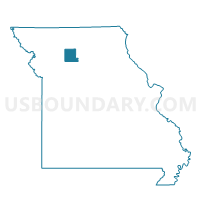
Wheeling Voting District, Livingston County, Missouri
About
Outline

Summary
| Unique Area Identifier | 609014 |
| Name | Wheeling Voting District |
| County | Livingston County |
| State | Missouri |
| Area (square miles) | 33.10 |
| Land Area (square miles) | 32.73 |
| Water Area (square miles) | 0.36 |
| % of Land Area | 98.90 |
| % of Water Area | 1.10 |
| Latitude of the Internal Point | 39.79937990 |
| Longtitude of the Internal Point | -93.39313560 |
Maps


Graphs
Select a template below for downloading or customizing gragh for Wheeling Voting District, Livingston County, Missouri


Neighbors
Neighoring Voting District (by Name) Neighboring Voting District on the Map
- Clay Voting District, Linn County, MO
- Grand River Voting District, Livingston County, MO
- Medicine Voting District, Livingston County, MO
- Parsons Creek Voting District, Linn County, MO
- Rich Hill Voting District, Livingston County, MO
Top 10 Neighboring County Subdivision (by Population) Neighboring County Subdivision on the Map
- Chillicothe township, Livingston County, MO (9,732)
- Rich Hill township, Livingston County, MO (1,406)
- Parson Creek township, Linn County, MO (856)
- Wheeling township, Livingston County, MO (411)
- Grand River township, Livingston County, MO (250)
- Clay township, Linn County, MO (248)
- Medicine township, Livingston County, MO (164)